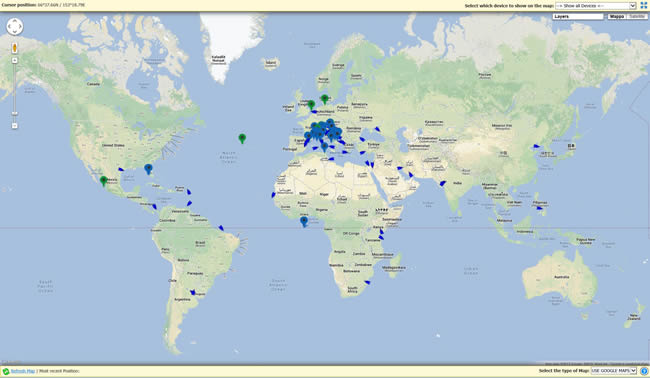
GEOBORDERS Tracking and Location Based services (LBS) is is a web based tracking and monitoring system that provides global access to monitor people, vessels, aircraft, M2M devices and fleets worldwide.
The portal runs on Geoborders Framework that is a secure multilingual platform offering both Satellite and GSM tracking solution on multiple maps with Various Layers including Satellite coverage, Meteo and Traffic Informations, User Defined Geofences, etc..
This service is offered for FREE for all people that own a satellite phone with a GPS like IRIDIUM Extreme, INMARSAT IsatPhone Pro (both Geoborders and non-Geoborders customers)
With FREE service you can see last 100 Positions of your Phone or device on different types of MAP and set the portal to forward your position to your friends, pubblish on Facebook or Twitter; with FULL SERVICE you can see last 1000 position of each device, export positions and remote ping devices.
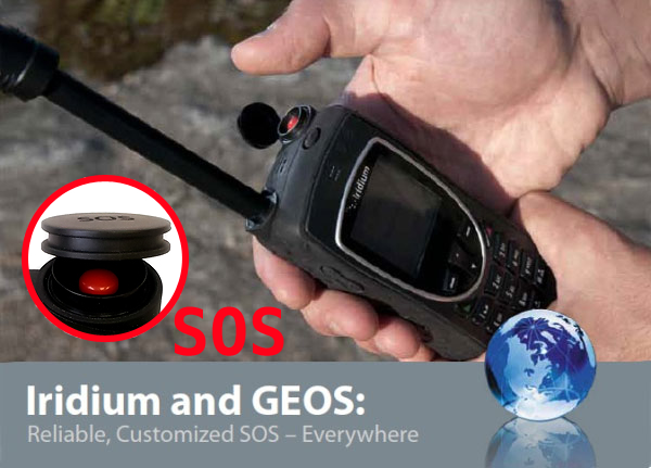
SOS Buttun:
A button that can save your life!

SOS Buttun can make the different in an emergency sityation.
Designed for simplicity, speed, and ease of use. Alert your loved ones can find you when you are in danger. Warn your friends and family of dangers or hazards near your area. Send Help is the ULTIMATE emergency SOS panic button of your device
Features:
- SIMPLE: one push starts sending alerts!
- PROGAMMABLE: Pre-define your emergency message and contacts -> Separate contacts for email and SMS
- GEOS SERVICE: optionally activate GEOS SERVICE emercency FIND & RESQUE
- Optionally: Post to your Facebook or Twitter wall to make sure more people helps you
- include your GPS location in a Maps link
- Location link will even open the Maps app on supported Smart Phones!
KEY BENEFIT
- With the cost of 1 SMS from your satellite phone you can inform all your loved or friends about where are you ad forward your position to some social networks as Facebook or Twitter
- No software required; Web based application works through the web browser on any computer, phone, tablet from office, home or on the go
- From Settings you can decide to forward messages with your position and a link of the MAP to many email address and publish your positions and messages on FACEBOOK and TWITTER
- EMERGENCY SERVICE SUPPORT: if your phone have an SOS button or if you type a message with written: “SOS” the portal will send an email with your position to a specific group of people that you can define and will send an SMS to a specific phone and optionally will ALERT SoS Authority
- The web portal allow you to keep secure your data and view positions over different kind of maps, Portal is hosted in world-class secure datacenter with 24/7 monitoring, redundant Internet connections, conditioned UPS power
MORE DETAILS:
- Fully suport your INMARSAT Isatphone PRO
- Fully supports Iridium Extreme 9575 features both stand alone or with Premium LBS portal subscription
- Fully support SHOUT NANO, NANO TOCHSCREEN
- TRACKING:The Portal can display the history of “last x known locations” over “y time period” visually on a map and you can set your handset to send automatic location report every xx minutes.
- GRUOUP MANAGEMENT: Display locations of all users, individual users or groups of users on maps
- MESSAGING: The Portal provide services to send email messages from the handset to an email recipient and to forward reply messages back to the handset
- EMERGENCY ALERT: The Portal will create a visual warning on the map in case of emergency alert message and will deliver email messages to one or more recipients as specified by the user upon receiving an emergency alert from the phone.
- FIND YOUR PHONE: If your phone have the PING function, Portal can perform a remote ping to request the handset’s location to request remotely the position of the phone; If your phone have the PING function, Portal can remotely configure automatic location report interval for each handset
| About LBS and Tracking Portal |
The LBS and Tracking Portal was developed by Geoborders in 2003 For Marittime Customers supporting Inmarsat services like Mini-C and skywave now after many years we support most commercial devices and all Satellite Networks (Iridium, Inmarsat, Globalstar, Thuraya) and GSM Devices.
HOW TO CHECK IF YOUR DEVICE IS SUPPORTED If you click on the top menu on "Tracking Devices" you will have the list of all supported devices, if your device is not on the list please contact us for integration.
HOW TO KNOW YOUR DEVICE SETTINGS TO MAKE IT WORK WITH THE PORTAL If you click on the top menu "Support" you will see a list of all device and a link for the PDF file with instructions for the specific device. You need Acrobat Reader installed on your computer or smartphone to see PDF files.
HOW TO FIND BEST AIRTIME PLAN FOR YOUR DEVICE Most of portable Satellite Phones do not need a special airtime plan to be used with the LBS & Tracking Portal because they can send the position directly via SMS or EMAIL. To use the tracking portal you can use your current airtime provider or choose Geoborders as your airtime provider, it is up to you!. To se available Airtime Plans for your device you can click on the Top menu "Tracking Plans" and select your Device from a list and you will se all available Plans connected to that device. |
| Om Geoborders |
Geoborders is an independent Mobile Satellite Communications Provider established in 1995. It is now one of the leaders in different commercial sectors and have a wide variety of clients worldwide, including individual travellers, large corporations, aid agencies, shipping companies, government departments and the military. Geoborders have HQ in London and distributes its product and services via wholesale and retail channels through its branches and partners.
|


 English
 French
 Italian
 Spanish
 German
 Swedish
